https://www.bmcb.be/communication-communicatie/

Forecasts for the next 42 hours
(BMCB Multimodel: ICOND2 – AROME-HD – ALADIN)
(These forecasts are usually updated daily)
Update 14 April 2026
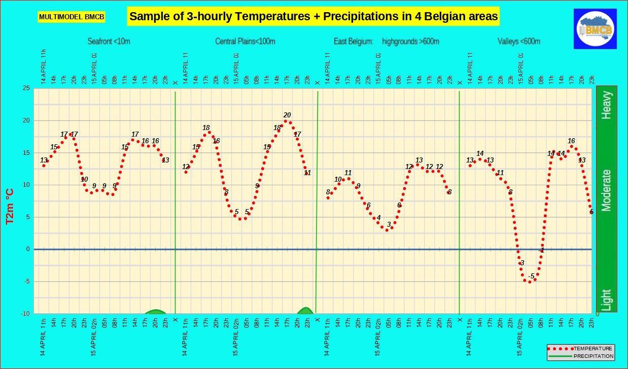
The next 42 hours will remain largely dry across the country. Expected precipitation amounts are minimal, ranging from 0 to 3 l/m² north of the Scheldt and between the Scheldt and the Sambre–Meuse line, and only 0 to 0.5 l/m² south of it.
Tuesday starts locally with patches of fog, followed by generally sunny conditions. A few cumulus clouds will develop mainly east of the Meuse and later south of the Sambre–Meuse line. Winds remain light and variable. Highs will reach around 17°C along the coast, 15 to 18°C inland, and 11 to 14°C over the higher Ardennes. The evening will be mostly clear. Overnight, skies remain largely clear with fog forming over central and eastern areas, and cool temperatures with a risk of local frost in some Ardennes valleys.
Wednesday begins fairly sunny, with high cloud more noticeable over the western half. During the afternoon, brighter conditions persist over eastern Flanders, Hainaut, Brabant, Antwerp and Namur, while cloud cover increases elsewhere. Southerly winds strengthen. Highs: about 17°C at the coast, 17 to 20°C inland, and 13 to 16°C in the higher Ardennes. During the evening, skies become cloudier with some light rain or scattered showers.
****************
National Thermal Indicator
MULTIMODEL BMCB
(These forecasts are generally updated daily)
Update 14 April 2026
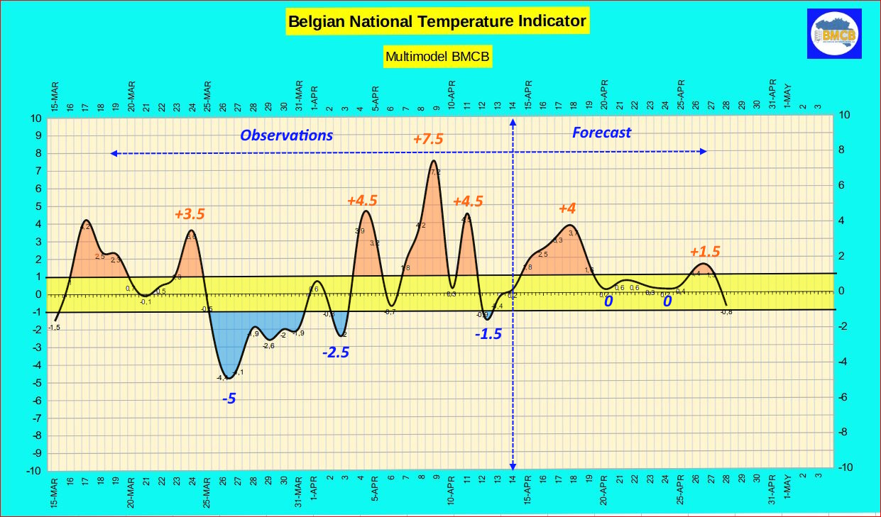
A gradual rise in temperatures has begun across our regions. The Belgian national thermal index is expected to steadily reach around +4, leading to daytime highs generally ranging between 14 and 21°C over the coming days.
After 18 April, this trend will weaken as the thermal index decreases, subsequently fluctuating between 0 and +2. Under these conditions, daytime temperatures will still range between 13 and 19°C during the mildest days, but will more often remain between 10 and 16°C, close to seasonal averages during less favourable periods.
****************
General Weather Evolution for the Next Days over the Ocean and Europe
Europe: Analysis & Forecast maps
Update 14 April 2026
A high-pressure ridge will extend over the coming days from the Bay of Biscay toward the southern Baltic Sea, with pressures between 1021 and 1023 hPa. This pattern will bring a weak southerly flow across our regions, allowing relatively mild conditions with some cloud intervals but little or no rainfall. 🌤️
On Saturday, a cold front associated with a 1003 hPa low moving eastward north of Scotland will cross the country, producing a few temporary rain periods. 🌦️
By Sunday, a high-pressure system centred near the Irish Sea (around 1024 hPa) will introduce slightly less mild but very stable air, resulting in generally calm conditions. ☀️
Outlook for 21–28 April:
A high-pressure area is expected to settle first over the North Atlantic and later maintain a ridge toward the British Isles. At the same time, a low-pressure zone will develop over Scandinavia. This setup would place our regions in a northerly to northeasterly flow gradually veering to north to northwest.
Under these conditions, weather is likely to become increasingly unsettled from 23 April onward, with more frequent precipitation and temperatures close to seasonal averages, without extremes. 🌬️🌧️
*****************
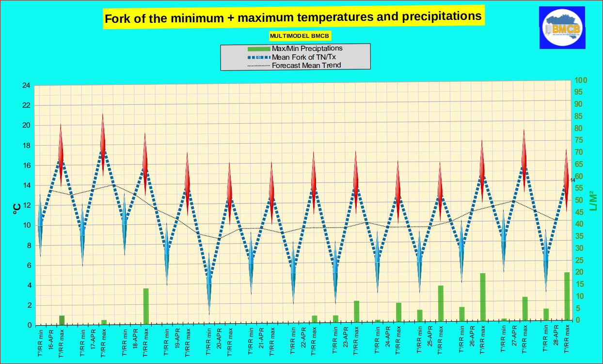
Forecast for the coming days
Multimodel BMCB ( OPERATIONAL + ENSEMBLES ICON-GFS-ECMWF-AIFS-GCGFS )
Forecast of the range of temperatures, precipitations + general type of weather in Belgium
(These forecasts are usually updated daily)
Update 14 April 2026
Expected evolution based on the BMCB multi-model
After some residual rainfall at the start of the period, conditions will remain generally calm and often dry until early next week. Thursday and Friday will feature alternating cloud and sunshine in mild to very mild air, with only a slight risk of showers, mainly across western and northern areas.
On Saturday, cloud cover will gradually increase after morning sunny spells. Rain or showers, possibly thundery, may develop in the afternoon, with fairly windy conditions in a west to southwest flow. Sunday should turn more stable and fairly sunny again, with mild temperatures.
Early next week will remain mostly dry, with sunny intervals and slightly cooler temperatures on Monday and Tuesday. A more unsettled pattern is then expected from 23 April, with more frequent rain or showers.
Between 23 and 27 April, conditions remain often mild but changeable, with occasional moderate rainfall. The weekend of 25–26 April could be wetter, with locally significant totals.
Towards the end of the period, around 28 April, a cooler trend is likely, accompanied by further rain or showers, locally quite marked.
*************
Trend of 500 hPa anomalies (around 5500m) across Europe and the Atlantic Ocean
ALL Maps
Update 9 April 2026
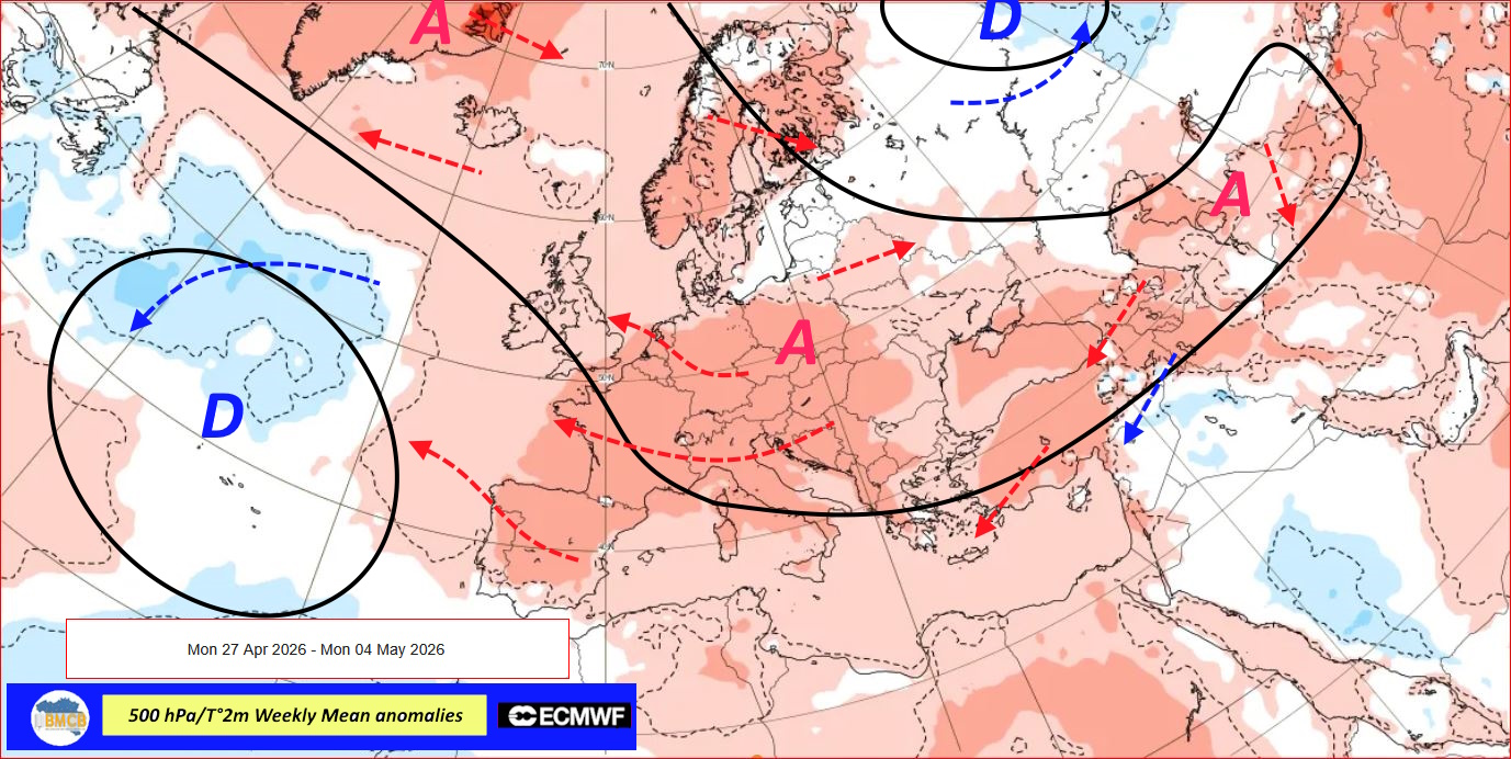
Outlook from 27 April to 11 May 2026
Medium-range projections indicate the persistence of a broad high-pressure block extending from Greenland across central Europe toward the Caspian region. At the same time, low-pressure conditions are expected to remain over the central Atlantic and northern Russia.
Within this pattern, our regions would lie on the southwestern flank of the anticyclonic system, under the dominant influence of a continental easterly flow. This setup would favour the establishment of dry and very mild air, with generally stable weather.
Rainfall and thunderstorm activity would mainly affect southern Europe, particularly eastern Spain, much of the Canary Islands, the Maghreb and the eastern Mediterranean basin.
For the period from 4 to 11 May, high pressure would persist over Greenland and the northern Atlantic as well as over eastern Europe. Our regions would then experience a very mild to warm southeasterly flow.
Rain and thunderstorms would become more frequent over the southwest of the British Isles, western France and the Iberian Peninsula, as well as over Scandinavia, while persisting locally over the central and eastern Mediterranean.
**************

SOURCE: METEOCONSULT
BENELUX:
Weather Outlook for 3-4 weeks
Weather Trend – Update 10 April 2026
Potential late-April warm spell followed by a more unsettled early May
Majority scenarios suggest that during the week of 27 April to 3 May, a warm and dry southerly flow may develop, leading to a renewed and marked rise in temperatures. Under this setup, near-summer conditions could temporarily establish across France and the Benelux, with locally high values possibly reaching or exceeding strong heat thresholds.
However, this evolution remains uncertain. Alternative model solutions favour a cooler and wetter scenario, which would limit the warming.
For the period from 4 to 10 May, covering early May holiday breaks, the trend points toward more disturbed conditions. The return of an unstable and moist Atlantic flow would bring more changeable weather. As temperatures would remain relatively mild, convective activity and thunderstorms could develop, particularly in a southwesterly flow.
This four-week outlook, updated every Thursday or Friday, remains subject to significant changes in upcoming revisions.
***************
Weather Outlook for 3 months
Update – 25 March 2026
La Niña weakening, El Niño possible for summer
Ocean-atmosphere indicators in the tropical Pacific show that La Niña is gradually fading, with neutral conditions expected during spring. Multi-model projections suggest this pattern could favor the emergence of an El Niño event during summer.
This transition may lead to a more variable atmospheric circulation, influencing precipitation and temperature patterns across several regions, including Europe. As a result, the weather signal becomes more volatile and less predictable.
April: often influenced by anticyclonic conditions, turning relatively dry. Temperatures near to slightly above normal (+0.5 to +1°C). Risk of late frost early in the month. Below-normal rainfall.
May: stable and rather dry. Temperatures around +1°C above normal. Frequently pleasant conditions. Slight rainfall deficit.
June: potentially warm start to summer with frequent thunderstorm development. Temperatures +1 to +1.5°C above normal. Highly variable rainfall with strong regional contrasts.
**************
from ICON (replace location left above )
from ECMWF (replace location left above)